
Mapping Roman Roads
- RW
- Nov 8, 2025
- 1 min read

A high resolution map of Roman roads throughout the Empire was published earlier this week: https://www.nature.com/articles/s41597-025-06140-z.
The map is open access at https://itiner-e.org/
It doesn’t really add to our knowledge locally, the lost portion of the road to the Mendips from Old Sarum (Sorbiodunum) remains lost. It is tempting to draw a straight line across the gap but as this route rises and falls across two valleys, and carts travelling it carried lead, there would have to be zig-zags. Other theories have this road (known as Margary 45b) swerving south to Wilton then turning to Old Sarum to cross what is now Bemerton Heath, or joining the south-west Sorbiodunum to Dorchester road, or coming via Camp Hill. Some lead brought along this route travelled as far as Pompeii.
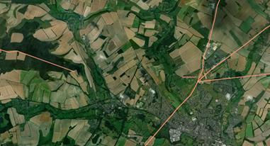
This image of the five roads that met at Old Sarum with a lost portion to the west is taken from the newly available dataset map at https://itiner-e.org/ created by Aarhus University Center for Humanities Co
Kerry O'Connor
A link to this newspost has been added to the Local History section of the website - see https://www.stratfordsubcastle.org.uk/maps-a-timeline