
Stratford sub Castle Village Website
Salisbury, Wiltshire UK

Old Sarum
.jpg)
Image: Model of 12th century Old Sarum - source Wikipedia
Old Sarum lies on the eastern boundary of Stratford sub Castle. Its hill has been the site of an iron-age hillfort, a Norman castle and a cathedral. The castle led to our settlement becoming known as Stratford under the Castle, (amongst other variations)
see name origin
North of Salisbury the ground rises rapidly from the west bank of the Bourne, and the high land thrusts out a narrow neck ending in a spur towards the Avon. On the north, west and south the spur falls away in steep banks: at the centre it rises, with artificial additions, to a height of 400 ft.
In a circle round the crest of the hill is the ditch of the Norman castle, enclosing an area of a little over an acre. In a wider circle, and fitting neatly within the 300 ft. contour line, is another ditch, which once enclosed the outer bailey of the castle and the cathedral church built by St. Osmund and Roger, Bishops of Salisbury.
The outer defence was first made in the early Iron Age, and its British name was Sorvioduni or Sorbiodoni. With the advent of the Saxons its name underwent a change, and the ending — dunum was replaced by burg or burh, each meaning a defensive place. The name appears as Searobyrg in the Anglo-Saxon Chronicle, and is Sarisberie in Domesday Book.
Source: https://www.british-history.ac.uk/vch/wilts/vol6/pp51-53
Old Sarum is an important local landmark. Local schools have included artistic interpretations of Old Sarum in their signage.

.jpg)


Links to our webpages about Old Sarum appear in the
Alternatively, click one of the links below.
Old Sarum - Neolithic evidence
Old Sarum - a Defensive Site
with a link to video 'Old Sarum from the air'
Old Sarum - images of the interpretation panels installed by English Heritage
William the Conquerer at Old Sarum
as described by Henry d'Avranches
Old Sarum - Parliament Tree & Rotten Borough
Old Sarum - the Pit, the Pile, the Possible Pillbox
Famous people who have lived at or visited Old Sarum
Travel Writers accounts of their visits to Old Sarum.
The Long History of Old Sarum - Alix Smith
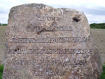
.jpg)
Image: 2019 Martin Cook (with permission)

Above - The Parliament Stone.
Below - The Mudge monument on the A345
.jpg)

WALK IT ! Details on the WALKS PAGE.