Stratford sub Castle Village Website
Salisbury, Wiltshire UK

The Mudge Mapping Monument
.jpg)
The Monument Stone and Cannon, commemorating the starting point of the first definitive mapping of Britain, on the A345 between Old Sarum and the Beehive.
.jpg)
In 1783 it was decided the astronomical observatories in Greenwich and Paris should have their relative positions fixed and in 1784 Major General William Roy (Royal Engineers) began the work by measuring distances using special chains. It took three years for Jesse Ramsden, one of Europe's finest instrument makers to construct his first theodolite (fig 1), the largest and most accurate instrument of its type in the world, before Roy could start measuring angles. A pair of part-buried cannon, five miles apart at Hampton near Twickenham and Hounslow Heath were used as markers for Roy’s first measured distance.
Triangulation was taken from there to the coast and then sightings were taken across the Channel and the process extended on to Paris. Several sightings including those across the Channel had to be taken at night using flares provided by the artillery.
.jpg)
fig 1 - Ramsden's
first theodolite
Ramsden’s first theodolite (fig 1) weighed over 90 Kg and Sir Joseph Banks provided a four wheel sprung carriage requiring two or four horses to move it.The instrument had to be winched out by crane (fig 2) for readings to be taken. Where there wasn’t a suitable high point it was hoisted up a thirty foot wooden tower.
Ramsden noted amendments suggested by Roy and built a second theodolite which the Board of Ordnance bought for the nascent Ordnance Survey (from the French 'ordonnance' relating to the organisation of military affairs). It was however the first instrument upgraded to the specifications of the second that was used here at Old Sarum by Captain William Mudge (1762 – 1820) (Royal Artillery).

fig 2 - the crane
This time the purpose was to map the south coast anticipating a French invasion, then the south and west inland and in time all of England. Mudge chose this site in 1793 but a clamp for the theodolite needed repair so he came back in June 1794, before the field was due to be ploughed, with twenty boxes of equipment used on the Hounslow Hampton site ten years earlier (Roy had died in the interim) and two metal chains for measuring distances (the temperature was factored in as was the curvature of the earth). He selected Beacon Hill, just east of Amesbury as the other end of his baseline and set about measuring its length. Using the carefully calibrated chains he undertook a series of measurements along the baseline, determining the difference in height and correcting for the topology at every step. In this laborious fashion he determined the distance to be 36,574 ft (11,253 m). A cannon was buried muzzle up at the Old Sarum end (see images below) and from this fixed point he started his survey. He sat in a tent and waited for the air to be still before taking measurements of the angle and elevation between Beacon Hill and two distant points - Four Mile Stone on the Devizes Road and Thorney Down. Making the same measurements at Beacon Hill allowed him, by simple trigonometry, to determine the exact position of these new points. This created new baselines for the next triangles and the survey proceeded. It has been estimated that Mudge’s survey was no more than 20m out across the length of Britain – a remarkable feat
.jpg)
The first definitive mapping survey of Great Britain therefore began here.

fig 3 - The local part of the principal triangulation mesh over Britain1860
Captain Mudge on Information Board on Old Sarum and circled in the distance, is the monument to him.
Roy rose to the rank of Colonel and died in 1790 but it was his work that led to the setting up of The Ordnance Survey in 1791. A Blue Plaque on his London home commemorates him. The cannon used to mark Roy’s first distance survive in situ. One is on the Northern Perimeter Road at Heathrow, the other in Roy Grove, Hampton. They and the address of the latter serve as monuments to his work.
Ramsden's first theodolite (fig 1) which Mudge used here, survived until 1940 when a direct hit by a Luftwaffe bomb on the Ordnance Survey in Southampton destroyed it. His second survives to this day in the Science Museum, London.
After the south of England, Mudge went on to survey the north of England, then Scotland, receiving a degree at Edinburgh University and rising to the rank of Major General. He became lieutenant-governor of the Royal Military Academy at Woolwich, a Commissioner on the Board of Longitude and Master General of H M Ordnance.
.jpg)
A large inscribed stone marking the nearer end of Mudge’s line was erected in 1967 by Master Masons (Freemasons) between Old Sarum and the Beehive alongside the A345 to Amesbury.
The inscription reads: "In 1794 a line from this site to Beacon Hill was measured by Capt W Mudge of the Ordnance Survey as a base for the triangulation of Great Britain."
The stone was knocked down in a road traffic accident in 2018 and righted in 2020. It remains there.
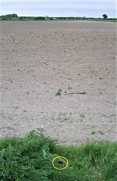
The cannon was commemorated by the Ordnance Survey on their maps, as “Gun, End of Base” to this day as a historic monument separate from the inscribed stone. It survives in situ, in a pig field, behind the monument stone. In winter it is visible from the pavement and stone, in summer it is overgrown and hidden. On the rim a benchmark is carved, it is 73.042 m above sea level. (Ordnance Datum Newlyn, see https://www.stratfordsubcastle.org.uk/benchmarks)
.jpg)
%20.jpg)
The cannon (circled, centre foreground), hidden at edge
of pigs' field
Sources
[1] An Account of the Trigonometrical Survey Carried on in the Years 1791, 1792, 1793, and 1794, by Order of His Grace the Duke of Richmond, Late Master General of the Ordnance. By Lieut. Col. Edward Williams, and Capt. William Mudge, of the Royal Artillery; And Mr. Isaac Dalby. Communicated by the Duke of Richmond, F. R. S Williams, E.; Mudge, W.; Dalby, I.; Duke of Richmond, Philosophical Transactions of the Royal Society of London (1776-1886). 1795-01-01. 85:414–591. Section Third. Measurement of the base of verification on Salisbury Plain with an 100 foot steel chain In the summer of the year 1794 pages 414 to 488
(and source for image fig 4.)
[2] The Tale of the Great Theodolites, Jane Insley of the Science Museum, 2008
[3] Historic England, the information board on Old Sarum
[4] Images fig 1 & fig 2 from Roy, William, 1790. Philosophical Transactions of the Royal Society of London volume 80 pages 111 et seq "An Account of the Trigonometrical Operation, Whereby the Distance between the Meridians of the Royal Observatories of Greenwich and Paris Has Been Determined".
[5] Image fig 3 extract from Clarke principal triangulation of Britain 1860, Wikimedia
https://commons.wikimedia.org/wiki/File:Clarke_principal_triangulation_of_Britain_1860.jpg
David Balston and Kerry O’Connor,
Stratford sub Castle Local History Group
May 2020
With the exception of figs 1-4, (sources credited above),all images on this page KMOC.

fig 4 - extract from Mudge's Survey
Further reading - an article on this website - First Edition Ordnance Survey Map of Stratford sub Castle and the Woodford Valley 1817
LOCAL BENCHMARKS -
Details of benchmarks around Stratford sub Castle are on this page.
