Old Sarum - eastern suburb
.jpg)
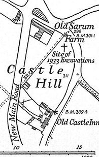
The old and new roads to Amesbury meet at the saddle between Old Sarum and the Bishopdown chalk ridge, now a country park. In the southern part of the island between these two roads is the Old Castle Inn (starred). In the north to northeast part lie the modern homes of Romans’ Rest, Legions’ Way, Windrush, East Gate and 15 Old Castle Road.
Quiz question no. 51 asked "What lay there in Norman to Plantagenet times?
The answer is - bodies.

Above: Old Castle Road, looking towards Castle Road (A345) & Hudson's Field
Below: Looking eastwards from Old Sarum to the Bishopdown chalk ridge.

This is the site of the probably main lay cemetery of Old Sarum in its eastern suburb. Skeletons have been discovered in this area in 1834, 1881, 1931, 1932 and 1933, nearly fifty in all.
To the west within the outer bailey near the cathedral(s) were more lay folk cemeteries and an ecclesiastical cemetery all linked more to the cathedral than the secular town. To the east at St John’s, lepers were buried in their own cemetery, separated in death as in life.
The 1933 excavations were two years after the new road was built and before the houses were built on the paddock site. As well as graves several Norman cess pits were excavated, in one a silver William I (the Conqueror) coin, minted in Wareham, was discovered.

Stone, JFS and Charlton, J. 1935 Trial Excavations in the East Suburb of Old Sarum.
The Antiquaries Journal XV plate XXIV opposite page 176 (the excavations were in 1933).

Left; Ibid; Plate XXIII, locating plate XXIV

Detail from August 1926 aerial view. Historic England Aerial Photo - EPW016856


Left. 1898 to 1939 3rd Ed ©Ordnance Survey map before the 1931 A345 new road was built. St John’s hospital has subsequently been located farther to the east, the location of the church of the Holy Rood or Cross is also uncertain and possible to the west. The tle of Castle Hill lies in a paddock, this is the cemetery site. Right The Paddock area today https://maps.bristol.gov.uk/kyp/?edition=wilts


The Paddock Area now with homes on it plus the 1935 Stone and Charlton map superimposed
Kerry O’Connor
September 2022
SOURCE Stone, JFS and Charlton, J. 1935 Trial Excavations in the East Suburb of Old Sarum. The Antiquaries Journal XV p174-192 https://archive.org/details/in.ernet.dli.2015.282002/page/n214/mode/1up?q=antiquaries+journal+XV
This article supplies the answer to Question No. 51 in the website's
Local History Photo Quiz.